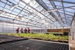
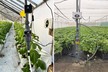
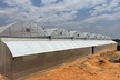
Inside the skyscrapers of Hong Kong and buildings worldwide, vertical farming startups are tending to trays of fruits and vegetables stacked floor to ceiling. In the space of just a handful of acres, these new farmers produce food indoors, year-round, in any climate.
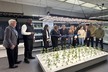
Supported by a geographic information system (GIS), indoor maps can guide agronomists, operations managers, and even robots through complex indoor environments, saving time and ensuring safety. But location technology generates more than virtual floor plans.
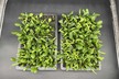
An indoor map of a vertical farm can show, for example, which crops are growing in different parts of a large, multistory building down to the floor and the vertical shelving unit. Operations leaders can get precise information at a glance, including where certain trays are in the growing process, the lighting conditions on a particular shelf or the ambient temperature in a specific grow room.
Ultimately, an indoor smart map populated with operational data could create a complete, 3D digital twin of a vertical farming facility. The concept of mapping an indoor farm parallels a practice emerging in more traditional industries: IT mapping. By mapping enterprise technology—from laptops and IoT devices to routers and servers—CIOs can monitor the IT heartbeat of an organization down to specific server racks and offices.
Read the complete article at www.esri.com.